
Following our time in New Mexico, we made our way to Flagstaff, Arizona so I could acquire my NOLS wilderness first aid certification. While there, we spent nearly two weeks exploring the city and the many surrounding national monuments and recreation areas. From the ruins of 1000 year old native American pueblos, to volcanic craters, and petrified rainforests, we got a diverse look into the environment and history of this area (also acquired a ton of patches). We then made the short drive to the grand canyon (very appropriately named). Here we enjoyed the incredible masterpiece that the Colorado river has spent millions of years creating. We capped off our time here with a 16 mile long rim hike, filled with insane canyon views and tons of lizards for the dog to chase.
We then continued our desert canyon tour with a nearly two week stay up in Dixie National Forest, directly between Zion and Bryce Canyon National Parks. These weeks were filled with breathtaking canyon views, red rock hikes, and forested adventures (also a lot of national park tourons).
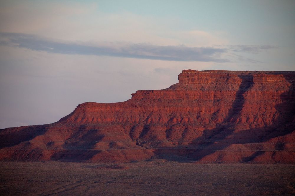
We finished off our Utah adventures with a drive to the eastern corner of the state, where we stayed amongst the red sandstone monuments towering across the desert landscape. Plenty of desert off-roading was done, as well as a day trip to Bears Ear national monument, and a sketchy hike down an old prospectors trail to the San Juan river.
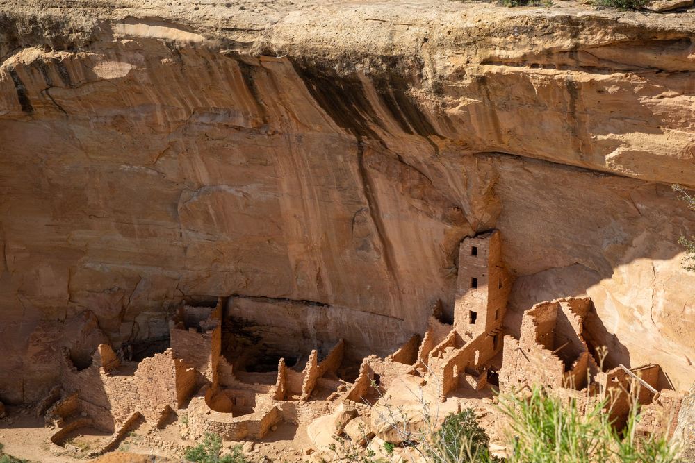
As we began our loop back to Texas, we made a quick stop in Four Corners, and spent a couple nights up at Mesa Verde National Park, where we saw some of the most impressive and well preserved Native American pueblos of our trip. This area was once a major hub of native Americans in the four corners region, and was pretty freaking awesome. Now back to good ole San Anton, with a couple short stops in Cochiti and Caprock Canyon!


Flagstaff and Surrounding
National Monuments & Parks
Petrified Forest National Park : Sunset Crater Volcano National Monument : Montezuma Castle National Monument : Wupatki National Monument : Walnut Canyon
Northern Arizona holds the kind of landscapes that rearrange your sense of time. Here, deserts shimmer with ancient fossils, volcanoes sleep under forests of pine, and stone walls whisper the stories of lives lived long before asphalt and headlights stitched these places together. Each turn in the road reveals a different chapter of Earth’s memory—etched in lava, layered in limestone, or frozen in the prismed rings of a petrified tree.
Perched at 7,000 feet beneath the San Francisco Peaks, Flagstaff feels more alpine than desert, with ponderosa pines rising from cooled lava and afternoon storms rolling in like clockwork. It’s a city shaped by its volcanic roots and framed by its forests. Once a bustling railroad and lumber town, Flagstaff now lives at the intersection of Indigenous heritage, modern science, and outdoor adventure.
To the east, Petrified Forest National Park unfolds like a surreal painting—striped badlands stretching across the horizon, dotted with logs turned to stone. These are the fossilized remains of a lush Triassic forest, trees that fell over 200 million years ago and, through a slow alchemy of minerals and time, became agate, quartz, and jasper. Their colors glint under the high desert sun, while nearby petroglyphs and ancestral ruins remind you that this land holds not just the memory of ancient Earth, but of the people who walked here long after the trees turned to stone.
Back near Flagstaff, Sunset Crater Volcano National Monument tells a much younger story—one of fire, ash, and rebirth. Less than 1,000 years ago, this cinder cone erupted, blanketing the landscape in black lava and crimson dust. The terrain is still raw and alien, a reminder of the Earth’s volatility. But it’s also a story of resilience: pines root through hardened lava, wildflowers bloom from cinder, and the land continues to heal in slow, determined ways. The eruption displaced ancient communities, but over time, life adapted—and returned.
Travel south to the Verde Valley and you’ll find Montezuma Castle, a five-story cliff dwelling built into a limestone wall like a hidden fortress. Crafted by the Sinagua people over 800 years ago, the structure perches above a rare desert riparian zone, where sycamores, cottonwoods, and willows trace the life-giving path of the Verde River. Despite its name—bestowed mistakenly by settlers—the “castle” is not a monument to royalty, but to survival. It stands as proof of ingenuity: how to live lightly, smartly, and sustainably in a land of extremes.
Not far from the lava flows of Sunset Crater lies Wupatki National Monument, a stretch of high desert where red sandstone pueblos rise from the earth like remnants of a dream. After Sunset Crater's eruption enriched the soil, people returned and built, creating multi-room structures, ball courts, and ceremonial spaces. Wupatki was once a bustling center of trade and culture.
Just east of Flagstaff, Walnut Canyon splits the forested plateau with a dramatic limestone chasm. Within its curving walls, dozens of cliff dwellings—also built by the Sinagua—nestle beneath natural overhangs. These were homes of stone and shelter, protected from the elements and suspended between forested rim and winding creek below. Hike along the canyon rim, and you’ll see not only these ancient rooms, but the tenacity of desert life: ferns in the shadows, prickly pear clinging to stone, and birds calling across time-sculpted cliffs.

Grand Canyon National Park
The Grand Canyon is not just a breathtaking landscape—it’s one of the most complete geologic records on Earth. Spanning 277 miles long, up to 18 miles wide, and over a mile deep, this massive chasm exposes nearly two billion years of Earth’s history in its layered walls. Every color band, every sheer cliff, every weathered ridge tells a chapter of a story written by time, water, and tectonic force.
At the bottom of the canyon lies the ancient Vishnu Schist, dark metamorphic rock formed nearly 1.8 billion years ago, when this region was part of a primordial mountain range. Layered above it are horizontal bands of sandstone, limestone, and shale—each representing vastly different environments across deep time. These formations—such as the Coconino Sandstone (formed from ancient desert dunes) and the Kaibab Limestone (once a shallow sea)—stack like a geologic library, showing how oceans, swamps, and deserts have all claimed this place.
The carving of the canyon itself began only around 5 to 6 million years ago, when the Colorado River began slicing through the uplifted Colorado Plateau. This was no gentle process—it was a relentless act of erosion, powered by water, gravity, and time. Rainfall and snowmelt deepened the canyon, while rockfalls and landslides widened its walls. Today, the river continues its patient excavation, deepening the canyon grain by grain.
Beyond the sheer rock, the Grand Canyon is a natural laboratory. Geologists come here to study tectonic uplift, erosion, and the dynamic forces that shape continents. Fossils embedded in the rock reveal extinct sea creatures and ancient shorelines, while faults and folds expose the Earth’s restless crust.
Even the sky contributes to this story. Thermal variations between the sunlit rim and the shadowed depths create microclimates, fostering unique ecosystems across different elevations. From desert scrub to alpine forest, life here mirrors the layers of stone—diverse, adaptive, and ancient.

Zion National Park
Zion National Park is a monument to the power of water and time. Its towering Navajo Sandstone cliffs—some rising over 2,000 feet above the canyon floor—were once massive desert dunes, laid down nearly 190 million years ago during the Jurassic period. Over eons, shifting climates transformed these dunes into stone, while tectonic uplift raised the Colorado Plateau, setting the stage for the relentless work of the Virgin River. Though modest in size, this river has carved through layer after layer of sandstone, creating Zion Canyon’s dramatic vertical walls, narrow slot canyons, and hanging gardens. The park’s visible rock layers span over 150 million years, capturing ancient rivers, swamps, and seas in horizontal bands of color and texture. Zion is a living geology lesson—its rock strata, cross-bedded cliffs, and seasonal waterfalls revealing the mechanics of erosion, sedimentation, and plate movement with stunning clarity.
Long before Zion was a national park, it was home to Indigenous peoples whose presence dates back thousands of years. The Ancestral Puebloans cultivated crops and left behind petroglyphs, tools, and cliff dwellings, while the Southern Paiute people later lived in harmony with the canyon's rhythms, calling it "Mukuntuweap," meaning "straight canyon." In the late 18th century, Mormon settlers arrived and named the area "Zion," referencing a biblical place of refuge. Their irrigation techniques helped them survive in the harsh desert climate, and remnants of their early settlements still dot the canyon floor. In 1919, Zion became Utah’s first national park, preserving not just a geological marvel but a cultural crossroads shaped by adaptation and reverence for the land. Today, Zion continues to evolve, with flash floods, rockfalls, and biological communities adapting to the vertical extremes and dynamic forces that define this iconic canyon.

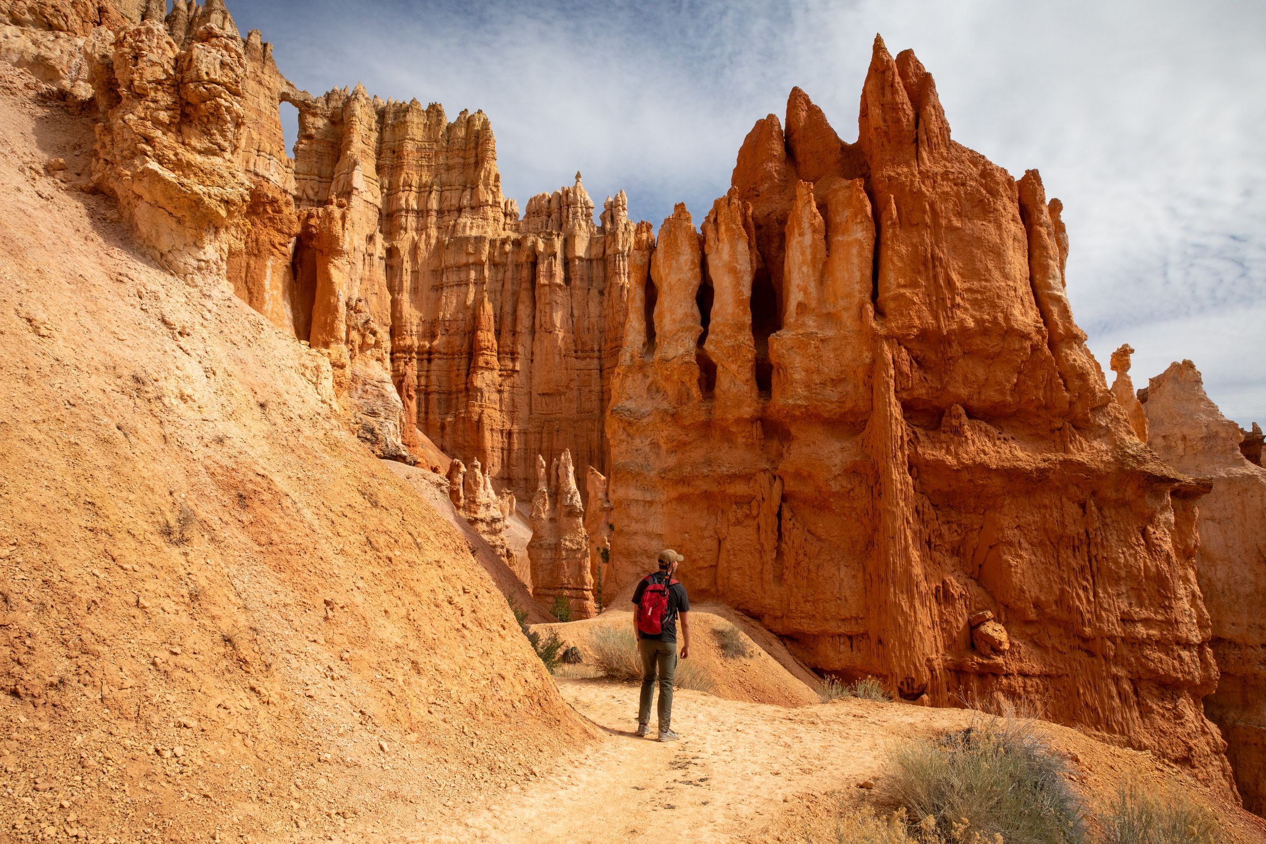
Bryce Canyon National Park
Bryce Canyon National Park is not a canyon in the traditional sense, but a series of amphitheater-like erosional basins carved into the eastern edge of the Paunsaugunt Plateau. The park is best known for its otherworldly hoodoos—tall, spindly rock spires sculpted by a unique interplay of frost-wedging and erosion. Composed mainly of Claron Formation limestone, these vibrant red, orange, and white layers were deposited 30 to 40 million years ago in a freshwater lake system. Over time, uplift raised the plateau, and seasonal freezing and thawing—over 200 freeze-thaw cycles per year—began to crack and chip away at the soft stone. Rain further dissolves the limestone, slowly carving out windows, fins, and eventually the surreal hoodoos that now crowd the landscape. The result is one of the most dramatic displays of erosion on Earth, where geology feels almost sculptural, frozen mid-transformation.
Human history in Bryce stretches back over 10,000 years, beginning with Paleo-Indians who hunted and foraged across the high plateaus. Later, the Fremont and Ancestral Puebloan peoples left behind rock art and artifacts, though the harsh winters and high elevation made permanent settlement difficult. By the 18th century, the Southern Paiute people inhabited the region, naming the land for its spiritual and ecological significance. In the late 1800s, Mormon settlers, including Ebenezer Bryce—after whom the park is named—began homesteading in the area. Bryce reportedly referred to the amphitheater as "a hell of a place to lose a cow," a phrase that belies the landscape’s overwhelming beauty. Bryce Canyon became a national park in 1928, preserving both the delicate geology and the layered cultural stories etched into this high-altitude desert. Today, it remains a dynamic classroom for understanding time, climate, and geology.
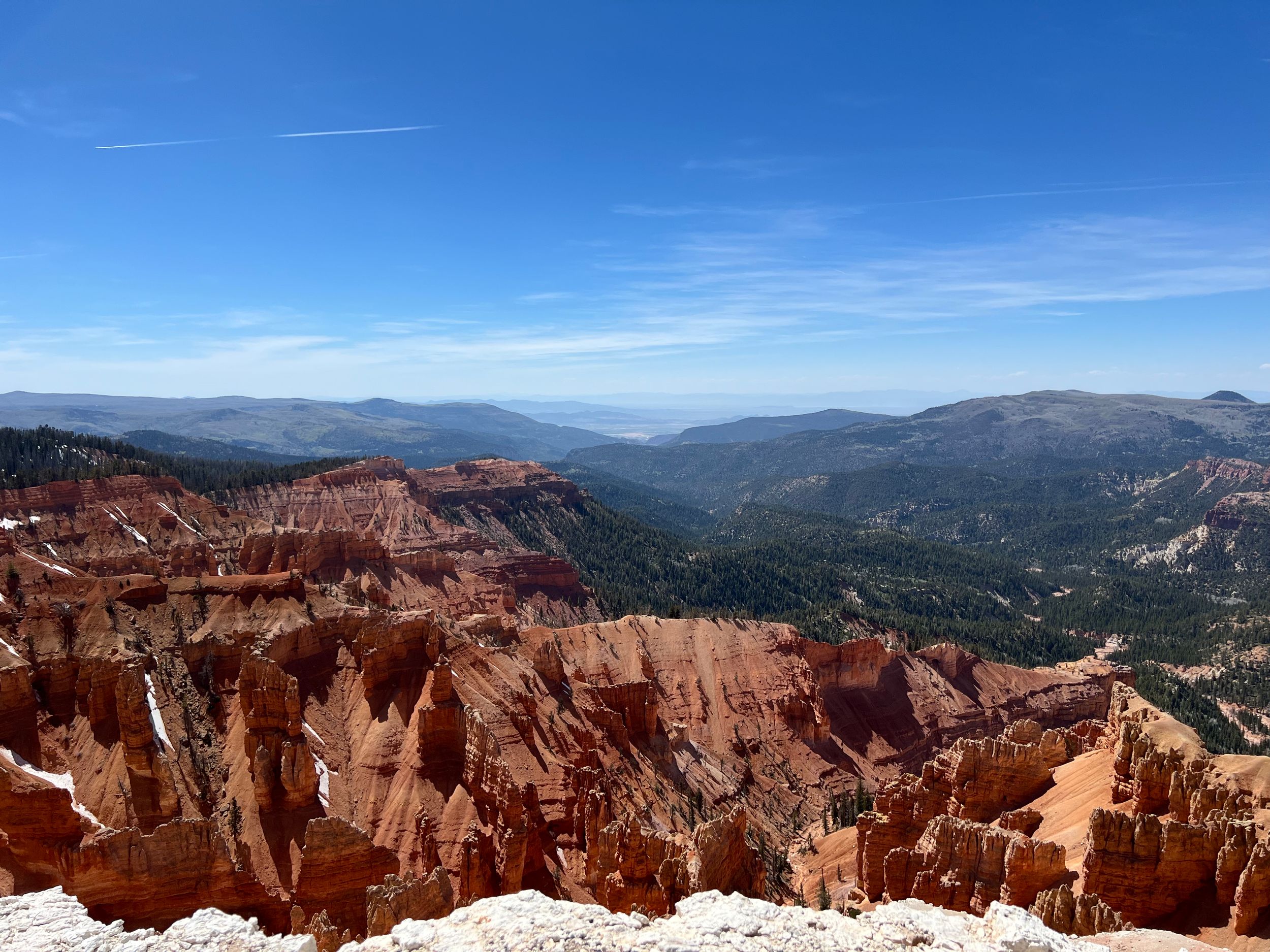
Cedar Breaks National Monument &
Dixi National Forest
Cedar Breaks National Monument is often called a "mini Bryce Canyon," but its geologic story is distinct and equally fascinating. Sitting at over 10,000 feet on the western edge of the Colorado Plateau, Cedar Breaks reveals a naturally eroded amphitheater more than 2,000 feet deep, carved into soft layers of Claron Formation rock. Over millions of years, tectonic uplift raised the Markagunt Plateau, exposing ancient lakebed sediments to the relentless forces of frost, rain, and wind. Like Bryce, the hoodoos here are shaped by freeze-thaw cycles, but the higher elevation and subalpine climate lend them sharper edges and cooler tones. The colorful spires, fins, and ridges—painted in pinks, oranges, and purples by iron and manganese oxides—are framed by spruce-fir forests and alpine meadows, creating a stark contrast between stone and sky. The monument also lies along a geologic transition zone, where the edge of the Basin and Range province meets the uplifted plateaus, offering a clear visual record of the Earth’s dynamic crustal movement.
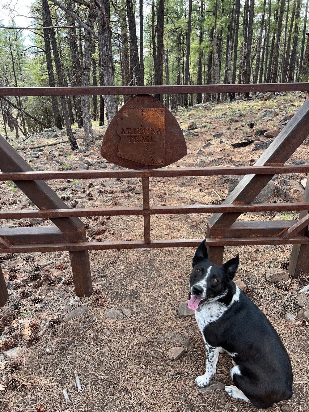
Adjacent to Cedar Breaks lies Dixie National Forest, a sprawling 2-million-acre landscape that stretches from the high plateaus of the Markagunt and Aquarius ranges down into red rock canyons and desert basins. This forest contains some of the most ecologically diverse lands in Utah, thanks to a vast range of elevations—from under 3,000 to over 11,000 feet. These lands have been home to Indigenous peoples for thousands of years, including the Fremont and Southern Paiute cultures, who hunted, gathered, and traveled through the region's varied environments. When European-American settlers arrived in the 19th century, they utilized the forest for grazing, timber, and water, and the area was officially designated as a national forest in 1905. Today, Dixie preserves not only natural resources and critical watersheds, but also evidence of ancient trade routes, rock art, and early settler homesteads. Together, Cedar Breaks and Dixie offer a living mosaic of Earth’s geological power and human adaptation across centuries.
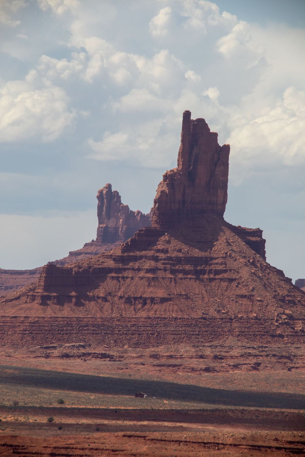
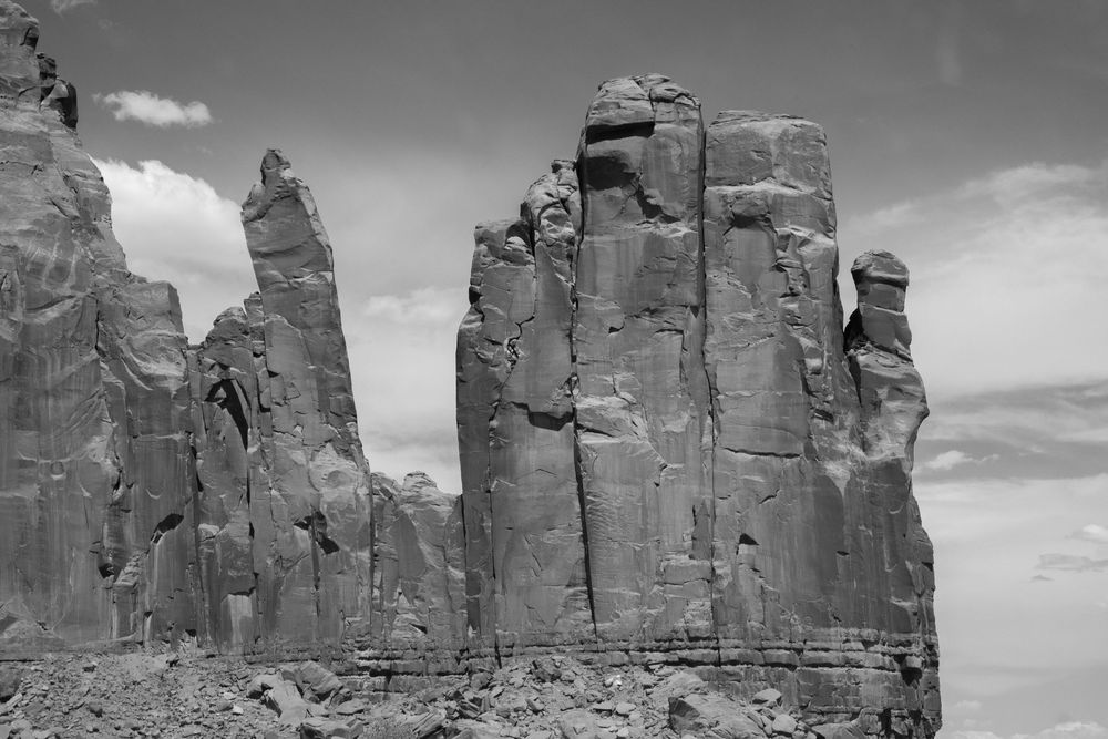
Monument Vally
Monument Valley is one of the most iconic landscapes in the American Southwest—its towering sandstone buttes rising like ancient monoliths from the flat desert floor. Geologically, the valley is part of the Colorado Plateau, shaped over hundreds of millions of years through the deposition of sedimentary rock layers, followed by slow, persistent erosion. The buttes themselves are remnants of cutting and weathering, where wind and water have stripped away softer layers, leaving behind the towering spires and mesas of De Chelly sandstone we see today. With vivid red hues from iron oxide and the crisp blue of desert sky, Monument Valley offers a visible timeline of Earth’s erosional power and deep geologic history. Though it appears still and timeless, the landscape is dynamic—constantly shaped by flash floods, shifting sands, and the grinding work of wind.
Yet the story of Monument Valley is not just geological—it is deeply human and political. The land lies within the Navajo Nation, and its formations are sacred to the Diné people, who have lived in the region for centuries and whose cultural narratives are intertwined with the buttes and mesas. In the 20th century, Monument Valley became an American symbol—popularized by Hollywood Westerns—while the realities of Indigenous sovereignty and land rights remained largely overlooked. Though featured as a backdrop for myths of frontier freedom, the valley is in fact a place where the long history of colonization, dispossession, and survival plays out against a cinematic sky. Today, the Navajo Nation governs access to Monument Valley Tribal Park, asserting cultural and political control over a landscape that has long been misrepresented. Visiting this place means seeing beyond the postcard view—to understand the land as both a geological wonder and a living emblem of resistance, reverence, and Indigenous stewardship.

Bears Ear National Monument & Greater Area
Bears Ears National Monument is a landscape of profound geological and ecological significance. Situated in southeastern Utah, the region is a vast and rugged expanse of mesas, canyons, buttes, and rock formations sculpted over hundreds of millions of years. Composed of ancient sandstone layers—including the Cutler, Cedar Mesa, and Navajo formations—Bears Ears tells a story of shifting seas, desert dunes, and deep tectonic uplift across geologic time. The area is rich in biodiversity, where piñon-juniper woodlands and high desert ecosystems support a wide array of plant and animal life. Its namesake twin buttes—visible from miles away—stand as silent sentinels over a land shaped not only by erosion and weather but by thousands of years of human presence.
That human presence is central to Bears Ears’ story—and its political struggle. The monument holds over 100,000 cultural and archaeological sites, including cliff dwellings, petroglyphs, kivas, and sacred landscapes significant to Indigenous tribes such as the Hopi, Navajo (Diné), Ute, Zuni, and others. For generations, these communities have gathered medicinal plants, performed ceremonies, and passed down stories tied to this land. In 2016, after sustained tribal advocacy, President Obama designated Bears Ears as a national monument—a landmark act of Indigenous-led preservation. But in 2017, the monument’s boundaries were drastically reduced by presidential proclamation (President Trump) , sparking legal battles and national debate over land management, extraction rights, and tribal sovereignty. In 2021, the boundaries were fully restored, reaffirming Bears Ears not just as a monument to natural and cultural history, but as a turning point in the ongoing dialogue around public lands, Indigenous leadership, and environmental justice.

Gooseneck State Park
Goosenecks State Park is a geologic marvel—home to one of the most striking examples of entrenched river meanders in the world. Over 300 million years of sedimentary rock are exposed in the park’s layered cliffs, where the San Juan River has carved a dizzying, snaking path through the Paradox Basin. These deep, looping bends—known as “goosenecks”—formed as the river slowly incised downward through the rising Colorado Plateau, preserving a sculptural cross-section of Earth’s geologic history. Standing at the rim, visitors look down more than 1,000 feet into a twisting canyon carved not by cataclysm, but by patient, persistent erosion. The terrain is a textbook of fluvial geomorphology, capturing the interplay of tectonics, time, and water in a landscape that looks almost too precise to be natural.
But Goosenecks is more than a geological wonder—it is part of a culturally rich and politically charged region. The park lies near the boundaries of Bears Ears National Monument and within lands traditionally stewarded by the Navajo Nation. While the state manages Goosenecks as a public park, much of the surrounding area is at the heart of ongoing debates over federal versus state land control, resource extraction, and tribal sovereignty. The scenic views often overshadow the deeper story of whose land this is—and how it's used or protected. Proximity to Bears Ears brings Goosenecks into the broader political dialogue about Indigenous co-management, sacred landscapes, and public land protections in the American West. It’s a place where Earth’s long past is laid bare in stone—and where the present remains deeply entangled in questions of justice, access, and memory.

Mesa Verde National Park and 4 Corners
Mesa Verde National Park is one of the most significant archaeological sites in North America—where the intersection of geology and human ingenuity is carved directly into the cliffs. The park sits atop a high plateau in southwestern Colorado, where ancient seas once deposited the layers of sandstone and shale that now define the steep canyon walls. Over time, water erosion sculpted deep alcoves into the softer Cliff House Sandstone, creating the perfect natural shelters that would later become homes for the Ancestral Puebloans. These formations—formed over millions of years—provided both protection and insulation, enabling the development of the famous cliff dwellings that make Mesa Verde a marvel of adaptive architecture. Beyond the cliffs, the park’s mesa-top environment hosts piñon-juniper forests, arid grasslands, and fragile desert ecosystems shaped by a delicate balance of elevation and rainfall.
Human history at Mesa Verde spans over 1,000 years, beginning with early basketmaker cultures and evolving into a complex society that constructed more than 600 cliff dwellings by the 12th century. These multi-story stone villages—built with remarkable engineering skill—were part of a larger cultural network that spanned the Four Corners region. The reasons for the eventual departure of the Ancestral Puebloans in the late 1200s are still debated, with drought, resource strain, and social upheaval all likely playing a role. When European-American settlers began to “discover” the ruins in the late 1800s, many structures had already endured centuries of exposure and looting. In 1906, Mesa Verde became one of the first national parks established specifically to preserve cultural heritage, not just natural beauty. Today, it remains a place of both reverence and research—a living classroom for understanding how people shaped, and were shaped by, their environment.


